As is well known, weather can increase the risk of wildfires and make it more difficult to extinguish them. But the relationship between fire and weather goes further: sometimes wildfires can generate their own meteorological phenomena, such as pyrocumulus and pyrocumulonimbus. These are clouds created by the extreme heat of wildfires, which can trigger powerful storms. Below, we explain how they form, why they are so dangerous and what we can do.
How are they formed?
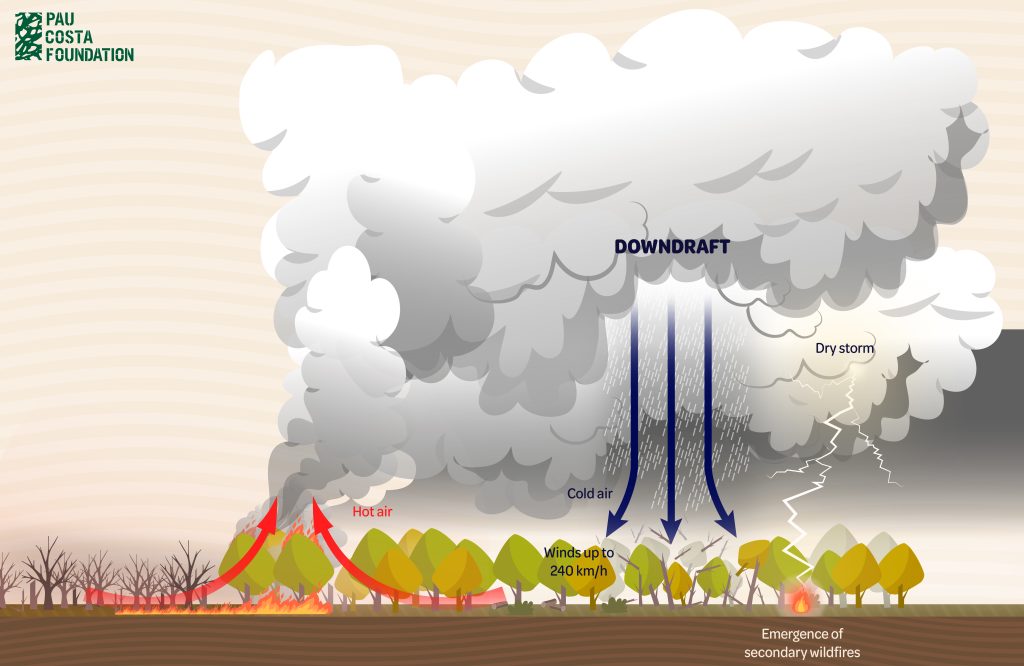
Imagine a forest fire. When vegetation burns, large amounts of heat are released. This causes the air near the ground to heat up and rise rapidly, generating a strong upward current. This empty space is quickly filled by cold air, thus generating convective currents.
As the warm air reaches higher layers of the atmosphere, it cools and expands. When the temperature is low enough, the water vapour in the air begins to condense and forms a cloud above the smoke column.

It is what is known as a pyrocumulus, a formation that can grow up to about 5,000 meters in altitude and that contains liquid water that can precipitate in the form of rain.
However, these formations can grow even larger and transform into pyrocumulonimbus. This process usually happens when the fire releases large amounts of heat and weather conditions allow it, regardless of the size of the fire. In these cases, the column of smoke is increasingly larger and higher and can reach up to 14,000 meters of altitude where the temperature is low enough to freeze the water droplets inside the cloud and form ice crystals.

Pyrocumulus and pyrocumulonimbus are therefore thunderclouds that form in a similar way to cumulus and cumulonimbus clouds. In this case, however, the heat source that warms the air that will form the cloud comes from the intense fire of wildfires. For this reason, the prefix pyro is used, which means fire in Greek.
Why are they dangerous?
As storm clouds, they can trigger typical phenomena such as lightning and thunder and even very localized heavy rains, but the problem is that they also have the ability to generate extreme weather phenomena such as downdrafts.
This phenomenon occurs when hot air currents from the fire reach high layers of the atmosphere where the temperature is low, the air cools and suddenly falls to the surface. Upon reaching the ground, the air disperses violently, generating extremely strong gusts of wind of up to 240 km/h that can uproot and break several trees, and produce erratic and unpredictable behavior, among other violent phenomena that makes the management and extinguishing of the fire more complex, putting the professionals who are working there in danger.
In turn, these violent gusts of air cause the fire to burn more intensely as they provide oxygen to the combustion process and can also transport embers or flames further away and cause secondary fires far from the original source.
In other cases, dry storms can also occur. The high temperatures reached during the fire cause the relative humidity to be very low and the precipitation to evaporate before reaching the ground. As a result, there will be no rain to extinguish any new fires caused by lightning.

What factors promote its formation?
This kind of cloud formation depends on atmospheric conditions and also on the energy that the fire is able to release during the wildfire. Scientists are currently working to determine exactly what these atmospheric conditions are. However, there is extensive knowledge about the factors that make fires to release large amounts of energy, thus facilitating the formation of this type of cloud. Below we detail them:
Forest fuel
The large amount of dead vegetation continuously distributed throughout the territory due to the lack of forest management, combined with the effects of climate change, will cause wildfires to burn more intensely.
Drought influence
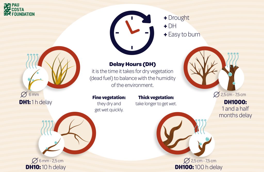
When we talk about dead vegetation or dead fuel, we are referring to fuel that does not have the capacity to regulate its own humidity and therefore depends on ambient humidity. Therefore, in conditions of drought and high temperatures, dead fuel will have difficulty hydrating and will burn more easily.
A practical and approximate method to determine the time it takes for dead vegetation to achieve equilibrium with ambient humidity is to calculate the delay hours.
Normally, in grasses and twigs, the delay can range from 1 to 10 hours. While in branches and trunks, this can be up to a month and a half as long as the relative humidity is favourable over time.

In a context of extreme drought, fuels with higher RH, i.e. thicker branches and trunks, do not manage to balance their moisture with that of the environment and therefore, will be able to burn when under normal conditions they would not or it would be more difficult for them to do. So wildfires will have more fuel available and will therefore be more extreme, releasing more energy and more convection, making it easier for pyrocumulus and pyrocumulonimbus to form, provided the atmospheric conditions are right.
Fire dissemination patterns
How the fire progresses and behaves in a wildfire are also determining factors in the appearance of this type of cloud.
Among the different dissemination patterns (topographic, wind and convection), convective fires, i.e. those that generate a convective column of hot air resulting from the release of large amounts of heat (energy), will facilitate the formation of pyrocumulus and pyrocumulunimbus. The extreme fire environment generated during the fire will involve great heat and strong wind currents that will contribute to the appearance of this type of clouds.
What to do?
Firstly, establish extinction strategies and tactics that avoid putting firefighting services at risk. It is very important that they pay special attention to the rise of pyrocumulus or pyrocumulonimbus clouds and withdraw from the area of action in time to possible changes in fire behavior avoiding risky situations in the event of a downbrust.
As a society, we need to be aware of the importance of landscape management to prevent fires from becoming large fires capable of generating phenomena such as pyrocumulus and pyrocumulonimbus that lead to risky situations.
Achieving a diverse landscape that offers opportunities to manage the spread of fire is essential. Doing so is in our hands through forest management and improving the rural economy.
Finally, it is also essential to increase knowledge about these types of clouds, as there are still many questions about its formation, behaviour and evolution. That is why, through European projects such as EWED, funded by DGECHO and coordinated by the Pau Costa Foundation, work is being done to shed light on this type of meteorological phenomena associated with forest fires.


